Monday, February 20, 2017

MT. PULOT ITAAS: "Hiking the Top of Mt. Honey Top, A Peek from the Peak of Dela Paz, Batangas City"

MT. PULOT AS VIEWED FROM THE ROAD TO JUMP-OFF
MT. PULOT ITAAS
"Hiking the Top of Mt. Honey Top, A Peek from the Peak of Dela Paz, Batangas City"
By: Ramon Q. Gayas Jr. (Ser Montaineer)

Acknowledgement: I Ramon Q. Gayas Jr. would like to extend my gratitude to all the people who helped in making this article possible especially to the following persons: Honorable Chairwoman Benita D. Zapata, Secretary Rufina Arellano and Panaligan Family who served as our host in Brgy. Dela Paz, Pulot Itaas, and to the local guides assisted us in exploring Mt. Pulot. I would also like to thank my team who joined me in the exploration: Monna Policarpio, Jep Erenio, and Michael Schwarz, as it would have been close to impossible to have succeeded without their support.

OVERVIEW

BCMR AS VIEWED FROM TIBIG-BANOI RANGE
A panoramic landscape commonly seen from the coast and peaks in the southernmost tip of Batangas. Stands near the span of Verde Island Corridor, resembles a twin peak image aligned with the foothills of Mt. Tibig-Banoi Range, and impressive to behold coupled with clouds and twilight illumination. Introducing --- a beautiful peak nestled in Batangas City Mountain Range (BCMR), Mt. Pulot Itaas. The place formerly use for "kaingin", but more remarkable as source of the sweet medicinal "honey" locally known as "pulot" - where the name of the mountain and its neighboring communities was derived - is a great potential hiking destination which offers blissful sights and adventure; from challenging road to pleasant community, exciting trails up to rewarding viewing point.


JEP, MONNA, MIKE AND THE BLOGGER
Mt. Pulot was frequented by some tree planters from the University of the Philippines Los Banos (UPLB) a decade ago. While the past three years of progressive hiking scene in Lobo Batangas gives exposure to it, which eventually piqued the interest of many hiking enthusiasts, especially those who climbed the Mt. Tibig-Banoi range, where it is largely overlooking along with the highlands of BCMR including the Mt. Pinamucan. In December 2016, the Lobo Batangas-based research team lead by Batangas State University Professor Anacleto M. Caringal made consecutive visits at the community of Brgy. Dela Paz, Pulot Itaas and studied the existing Philippine Teak (Tectona Philipinensis) forest. The blogger is part of the research team, and that event made him able to check out the Mt. Pulot's hiking potential. Furthermore, last February 11 to 12, 2017 he and his hiking team conducted an exploration climb and scribed the exploratory trail, viewing point and bushy summit of Mt. Pulot.

The Entry point and Jump-off

The community of Dela Paz, Pulot Itaas, Batangas City serves as the jump-off point in climbing Mt. Pulot. However, take note that there are communities in the location which bear the name "Dela Paz" and "Pulot" to avoid confusion, these are the Brgy. Dela Paz Proper, Brgy. Dela Paz Pulot Aplaya and Brgy. Dela Paz Pulot Itaas, or the jump-off itself. This is accessible via Batangas City-Tabangao Road and Poblacion, Lobo Batangas, which is approximately entail 3 to 4 hours travel from Manila. Passing whichever route will bring the trip along the coastal road leading the way to De Lapaz, which eventually detours to community road locally dubbed as "Pulot Ibaba" (Entry Point), near the notable Elementary School of Brgy. Dela Paz, Pulot Aplaya. As of February 12, 2017, there is no regular means of transportation passing at the road connecting Pulot Ibaba and the Jump-off. Taking tricycle might be inappropriate as the road is steep. However, those who have four-wheel vehicle service may directly proceed to Pulot Itaas. While commuters alight at Pulot Ibaba has an option to ride through rented single motorcycle, or trek the road which will take 1 hour up to the Jump-off point. Though challenging and almost similar with the first leg of hiking Mt. Gulugud Baboy via Philpan, the trek up via community road is manageable. There are several rest stop point and views ahead. In fact, there is waiting shed along the way and several open areas that gives way to see the closer view of Mt. Pulot, portion of Verde Island Passage and Islets of Calapan Mindoro.

In Pulot Itaas' community, trekkers are required to drop by at the Brgy. Hall or house of Chairwoman Benita D. Zapata, for courtesy call, registration, and get local guide assistance. The well-known mountain guide in the place is Geminiano Ebora, a longtime resident in Pulot Itaas and popular harvester of honeycomb in Mt. Pulot. He might assist hikers in climbing the said mountain. Interestingly, the village of Pulot Itaas was recognized as one of the Livable Place in Batangas City in year 2015. There is also a "heart-shaped" rock formation located along the community trail prior to the last houses in the area.

MT. PULOT AS VIEWED ALONG THE ROAD TO JUMP-OFF
TRAIL ILLUSTRATION COURTESY OF JEP ERENIO
HEART-SHAPED ROCK FORMATION
Trail to Bigaan Campsite/View deck

After passing the community, the trek to Mt. Pulot recommence inside the typical environs; which holds intermittent stream channel and woodlands with occasional presence of bamboos and fruit bearing trees, mostly Mango and Tamarind. Surveying through this way will bring the adventure to upslope and exposed terrain that is widely conquest with shrubs and many thorny plants. Nevertheless, one may feel the excitement while taking the way up, as it gives initial sightings to the combined landscape of Batangas City-Lobo and span of Verde Island Corridor, which is also impressive if viewed from the view deck along the forest of Mt. Pulot.

COASTLINE OF BATANGAS CITY-LOBO
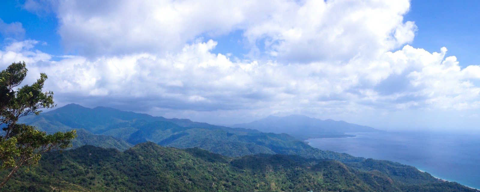
The trail leading to the forest is quite challenging. It gives trial of steep ascent and hindrances cause by shrubs and thorny plants, yet will further headed to "Bigaan". One place in the forest of Mt. Pulot that is formerly rich in "Alocasia Macrorrhiza" otherwise known as "Biga". A nice rest stop point which require 2 hours of ascent from the Jump-off, possess potential campsite good enough for 3 to 5 tents, has a small viewing cliff (500+masl, unverified) which may accommodate 8-10 persons, and offers splendid scenery. However, hiker must give careful attention to ensure safety while exploring the "Bigaan View deck". At this point, one can see the magnificent coastline formation lining beneath the combined landscape of Batangas City-Lobo; from Pulot's foothills to the highlands of Talahib Pandayan, Mt. Tibig-Banoi Range to Lobo-San Juan Mountains (LSJM). While the Islets of Calapan Mindoro are looks looming decors rises over the Verde Island Corridor.

MT. TIBIG-BANOI AS VIEWED FROM BIGAAN VIEW DECK
COAST AND LSJM AS VIEWED FROM BIGAAN VIEW DECK
THE PANORAMIC SCENERY FROM BIGAAN VIEW DECK
MT.TIBIG-BANOI, LSJM AND COAST OF BATANGAS CITY-LOBO
SUNRISE VIEW FROM BIGAAN VIEW DECK
The Summit and other viewpoint

On the other hand, climbing the summit (Sta. Maria Peak, 655+masl, unverified) is optional. There is no clear view on top as it is entirely obstructed with trees and full of overgrowth. But the 1 hour climbing distance of it from Bigaan may add enjoyment, considering there are slopes to pass which opens up for views and enable to feel refreshing coastal wind. Thrillingly, the hike to Mt. Pulot will be more rewarding if one is able to explore the other potential viewpoint (optional, exploratory). Indeed, there is another viewing cliff (564+masl, Unverified) aside from "Bigaan View deck" – requires an hour of trek from "Bigaan" but off the trail to summit - where one can glimpse to the extensive view consists of; Verde Island, Southeastern Batangas City Marine Corridor, Islands of Batangas Bay such as; Culebra, Tingloy, Maricaban and Sombrero, and slope of Mt. Gulugod Baboy.

Overall, Mt. Pulot is a pleasant sampler of rarely explored peaks in Batangas City Mountain Range. Together with the other attractions in the range that are yet to reveal, the resplendent sceneries, and exploratory spots within it, makes it an interesting peak to discover.

AT THE OTHER VIEWING CLIFF
PANORAMIC SCENERY FROM THE OTHER VIEWING CLIFF
VERDE ISLAND PASSAGE AND BATANGAS BAY
THE BLOGGER'S TEAM WITH CHAIRWOMAN BENITA D. ZAPATA
3D MAP ILLUSTRATION: MT. PULOT ITAAS AND IT'S RELATION TO THE OTHER PEAKS IN BCLSJM

ADDITIONAL INFORMATION

Destination’s Profile
Major Jump-off: Brgy. Dela Paz, Pulot Itaas, Batangas City
Elevation: 655+masl (Unverified)
Hours of Climbing: 3-4 hours
Days of Climbing: 1 or 2 days
Alternate trail: N/A as of February 12, 2017
Specs: Minor Climb
Difficulty: 3/9
Trail classes: Cemented road, woodland, farmland, forested trail
Features: Scenic view of coast and landscape of Batangas City-Lobo, Verde Island Passage, Batangas Bay, Exploratory
Transportation
(As of February 12, 2017)
For commuters:

P127 - BUS - Manila to Lipa Bus Terminal 

P120 - VAN – Lipa Bus Terminal to Lobo Poblacion

First Trip of Van from SM Lipa: 0630
Last trip of Van from Lobo: 1700
Last trip of Bus from SM Lipa: 2000
                
For private transportation: Head out your trip to Batangas City Diversion Road via SLEX Star toll-way, take the road heading to Batangas City-Tabangao-Lobo road and go through the way passing Dela Paz, Batangas City. Afterwards, detour the ride to Pulot Ibaba road near Dela Paz, Pulot Aplaya Elem. School. Ask the local folk about parking area. Approximately 3 hours travel time from Buendia, Taft Avenue.

For jeepney rental from Batangas City to Pulot Itaas: You may contact Kon. Reynaldo Ronquillo at 09465654255

For tricycle and jeepney service from Lobo, Poblacion to Dela Paz Pulot Ibaba: You may contact Romel Casilihan at 09077722052
Contacts and Coordination
Brgy. Chairwoman Benita D. Zapata 09295515662

Brgy. Secretary Rufina Arellano 09093370155

Brgy. Konsehal Reynaldo Ronquillo 09465654255
Registration
Register at Brgy. Hall of Pulot Itaas or at the house of Chairwoman Benita D. Zapata. No registration fee as of February 12, 2017
Guide fee / Guide assistance
Guide is highly recommended (new hiking destination)
P500 per guide recommended for day hike
P700 per guide recommended for overnight

Local Mountain Guide:

Ben Panaligan 09074494337
Rudy and Geminiano Ebora 09292939117
Kon. Reynaldo Ronquillo 09465654255
Water source
Available at the Jump-off area and at the trail above the community
Hiking notes and Precautions
Hiking trend status – Potential hiking destination with minimal record of hiking activities as of February 12, 2017

Reservation and Limit - There is no implementing ruling about reservation and limit as of February 12, 2017. Avoid mass climbing though

Prerequisite – 4 hours day hike experience is an advantage

Day hike – Highly recommended

Night trekking – Coordinate night trek plan before proceeding

Cell phone signal – Sporadic at the Jump-off but present at around 400masl

Amount of water to bring – 2 to 3L for day hike, 4-5L for overnight

Sun exposure – At the community road and above the community

River Crossing – Nothing major

Terrain condition – Gradual to upslope and slippery when wet. The trail from Jump-off to Bigaan is established, but exploratory up to the other viewpoint and summit (As of February 12, 2017)

Thorny Plants – Many prior Bigaan

Bladed Grass – Minimal

Rope segment – None

Limatik – None

Honeybee - Many during summer season as per local guide
Campsite / Camping notes
There are many potential campsites above the community, while Bigaan Campsite may accommodate 3-5 tents. Coordinate your camping plan before proceeding and bring enough water (4-5L).
Side Trip and Facilities
Beach at Dela Paz, Pulot Aplaya (near entry point) and Banalo-Masaguitsit Lobo, Batangas

Sing-sing na Bato coastal rock formation (along the coastal road heading to Lobo, Batangas

Shower area – At the Jump-off

Sari-sari store  – At the Jump-off
Estimated Budget
P1000


SAMPLE ESTIMATED BUDGET COMPUTATION

(For manila-based commuters passing Poblacion Lobo, Batangas)

Number of participants
4 persons
Duration
Overnight
Transportation
P254 - BUS - Manila to Lipa Bus Terminal (back and forth)

P240 - VAN – Lipa Bus Terminal to Lobo Poblacion (back and forth)

P150 per person – Tricycle service from Lobo, Poblacion to Dela Paz, Pulot Ibaba (back and forth)

Guide fee
P175 per person
Registration fee
Voluntary
TOTAL
P1000 (w/ P181 contingency fund)

SAMPLE ITINERARIES

Day Hike: For group with private vehicle

0330 Assembly at Buendia near LRT Gil Puyat Station, Breakfast
0400 ETD to Brgy. Dela Paz Pulot Itaas, Batangas City (Jump-off), Via Batangas City-Tabangao Road
0700 ETA Pulot Ibaba road (Entry point), head out the ride to Pulot Itaas
0715 ETA Brgy. Hall of Dela Paz Pulot Itaas (Jump-off), Courtesy call, Ask for parking, Register, Arrange guide
0730 Start trek up to Mt. Pulot
0915 ETA Bigaan View deck, Explore

Option: Trek to summit or explore the other viewing deck which may consume 1-2 hours (exploratory)

1300 Descent to Jump-off
1500 ETA Jump-off, rest and wash
1630 Head back to Manila
2000 ETA Manila

Overnight: For commuters passing Lobo, Batangas

Day 1

0530 Assembly at Buendia near LRT Gil Puyat Station, Breakfast
0600 ETD to SM Lipa
0800 ETA SM Lipa-Lobo Van Terminal
0900 Take van to Poblacion Lobo Batangas
1030 ETA 7-11 Poblacion Lobo Batangas, Buy Supplies
1100 Ride rented trike to Dela Paz, Pulot Ibaba road (entry point, near Elementary School of Pulot Aplaya, Batangas City)
1130 ETA Pulot Ibaba, Lunch and Preparation
1300 Start trek to Brgy. Hall of Dela Paz Pulot Itaas (Jump-off)
1400 ETA Jump-off, Courtesy call, Register, Arrange guide
1430 Resume trek up to Mt. Pulot
1630 ETA Bigaan Campsite/View deck, Explore, Set Camp
1800 Dinner and Socials onwards
2000 Lights out

Day 2

0500 Wake-up call, Sunrise viewing at Bigaan, Breakfast

Option: Trek to summit or explore the other viewing deck which may consume 1-2 hours (exploratory)

1100 Lunch and Break camp
1200 Descent to Jump-off
1400 ETA Jump-off, rest and wash
1500 Descent to Pulot Ibaba
1530 ETA Pulot Ibaba, Ride rented tricycle to Poblacion Lobo Batangas
1600 ETA Poblacion Lobo Batangas
1630 Take van to SM Lipa (5PM: last trip)
1830 ETA SM Lipa, Take Bus to Manila (8PM: last trip)

2030 ETA Manila

Wednesday, January 18, 2017

NALAYAG ROCKS AND MT. MASALAKOT: "Sailing the Rocks Wonder's Peek and Wide-Brimmed Hat Peak of Balibago"

NALAYAG ROCKS AS VIEWED FROM MT. MASALAKOT


NALAYAG ROCKS AND MT. MASALAKOT
"Sailing the Rocks Wonder's Peek and Wide-Brimmed Hat Peak of Balibago"
By: Ramon Q. Gayas Jr. (Ser Montaineer)

Acknowledgement: I Ramon Q. Gayas Jr. would like to extend my gratitude to all the people who helped in making this article possible especially to the following persons: Professor Anacleto M. Caringal of Batangas State University for providing relevant information, Lito Camo and his family who served as my host in Brgy. Balibago,  Demetrio Avila and Jerome Sulit the local guides assisted me in exploring Nalayag Rocks and Salakot Peak. I would also like to thank my hiking companions who joined me in exploring the features surrounds Nalayag Rocks, Punas valley, and the Monna’s Peak: Jep Erenio, Monna Policarpio, Rolven Ciriaco, and John Ryan Secretario, as it would have been close to impossible to have succeeded without their support.

OVERVIEW

NALAYAG-SALAKOT AS VIEWED FROM THE SEA
Behind the sea and hidden valley encompassing South-Eastern Lobo-San Juan Mountain Range rises "Nalayag Rocks" and "Mt. Masalakot" (Nalayag-Salakot), a set of potential outdoor destination sits at the mountainous complex of Brgy. Balibago, Lobo, Batangas. A logistically challenging site yet, an adventurous and presently gaining prominence in Lobo's hiking scene; which offers new trails to hike, rocks to climb and views to relish. Nalayag Rocks is a composition of elevated block, nestled at the ridge of Mt. Masalakot, contrast to some description calling it "Monolith" or Mt. Nalayag. It was imaginatively accounted by the local folks as "Nalayag", as it looks "layag" - sailboat's centerboard-shaped rocks formation - that is "nalayag" or "sailing" through the forest when viewed from the sea. However, If there is a place in the area that called mountain, that is no other than the Mt. Masalakot (Salakot Peak) which apparently bear the shape of "wide-brimmed hat" otherwise known as "Salakot", as per the local folks.

NALAYAG -SALAKOT AS VIEWED FROM MONNA'S PEAK
The Nalayag Rocks has been noticed by the blogger during their exploration at Mt. Tilos (640masl) in Brgy. Malabrigo on February 09, 2015. A year after (February 21, 2016), through the assistance of some local "habal-habal" drivers, the blogger was able to check it out via Sitio Punas in Brgy. Balibago, where he reached the rocks' bottom but didn't ascend the top due to rock climbing technicalities. He did another attempt on March 28 of the same year together with his team, but unfortunately missed the right trail. However, the said attempt surprisingly brought his group to the discovery of 600+masl (unverified) summit of Monna's Peak (named for blogger's hiking friend Monna Policarpio), one of the rare-explored sub-mountain in the area, which is a nice vantage point to capture the panoramic view of Nalayag Rocks together with Salakot Peak, Punas valley, Mt. Tilos range and nearby seascape. In order to see the other entry point to Nalayag Rocks, the blogger took another ocular visit a month after (April 25, 2016), via Sitio Maligaya, also in Balibago, and found out another trail heading to it.

On the other hand, recently one local guide based in Brgy. Malabrigo named Russel Sioco succeeded in exploring Nalayag Rocks. From then on, climbing up to the rocks became possible. While the interest of climbing the summit of Salakot Peak eventually arises. As of December 2016, there are different groups and individual ascended the rocks, but the hike to summit Salakot Peak that time is not yet push through. One thing the blogger did after climbing Nalayag Rocks - through the help of local guide - from the trail of Sitio Maligaya last January 08, 2017, the day that marks his journey to the 650+masl (unverified) summit of Salakot Peak. 

ZOOMED PHOTO: NALAYAG ROCKS AS VIEWED FROM MT. TILOS
THE BLOGGER'S TEAM (L-R) Jep Erenio, Monna Policarpio, Rolven Ciriaco
TRAILS TO NALAYAG-SALAKOT

The hike to Nalayag-Salakot is doable through the trails of Sitio Punas and Sitio Maligaya, both suitable as entry and exit point, hence, traverseable. However, take note that the accessibility of these trails might change depends on weather and trails condition, and policies may emerge in the future, considering there is other alternate route - in Sitio Langkaan, also in Brgy. Balibago - to reach the Nalayag-Salakot and there are areas in both trails that are privately owned.

"Sitio Punas as jump-off"

BEAK-SHAPED FORM OF NALAYAG ROCKS 
On the trail via Sitio Punas, the trek usually start in front of waiting shed near the coast that bound Malabrigo and Balibago, initially passes through rough road heading to Punas' community. The trail after the community offers view of Mt. Tilos, and passing this way will lead hikers to Punas Valley. Though hinder with occasional river crossing, trailing through Punas Valley may treat hikers to several mini-falls and small clear basin, which can be found near the place they called "piit" or "Punas' bridge". The streams in Punas Valley serves as refresher before passing the slanted woodland up to the farmland rich with sinturis and coconut trees. The said farmland is customarily use as resting place, good as rest stop point and potential as campsite. Additionally, the view of Nalayag Rocks is overlooking from it. After a minute of trek from the farmland, one will be able to see the gigantic beauty of Nalayag Rocks. Unbeknownst to many, it is turning to beak-shaped form when viewing it from the east. Then, the trek goes through the forest, that gives challenge of steep ascent and obstruction from some barb wire fence placed in the area, which then lead to Nalayag Point, the place where Nalayag Rocks is astride.

"Sitio Maligaya as jump-off"

"AHIT PEAK" AS VIEWED FROM THE TRAIL 
Trailing the way via Sitio Maligaya is shorter than in Sitio Punas. The trek originates from "sentro-balibago", where hikers primarily walk through cemented pathway surrounded with several houses and patch of coconut farmland, enough for warm up prior passing the upslope and exposed rough road trail. While going through the rough road, hikers could have initial glimpse to some interesting sceneries such as; blue Seascape of Balibago and the peak locally known as "Ahit", a place that is full of "ahit grass", perhaps, a potential viewing point. Thereafter, the hikes goes through gradual slopes; mostly shady, established, and an easy to negotiate terrain which possesses "koprahan" ground, and potential rest stop point. But follows with slanted and slippery forest trail (more challenging when wet), which sometimes requires hikers to grasp on some ropes placed in the area in order to reach the Nalayag Point.


"Sailing up to Nalayag Rocks"

The Nalayag Point may treat as midway of the combined Nalayag-Salakot hike. However, it’s up to hiker to decide for the itinerary sequence; wether climbing Nalayag Rocks first then next is Salakot Peak, or vice versa. Also, put into consideration that climbing Nalayag Rocks is a very dangerous activity.


WOODEN LADDER OF THE TALLEST BLOCK
At Nalayag Point, hikers may explore the blocks that composite Nalayag Rocks, any of these are potential for viewing; while the tallest one is the most exciting(?), gives thrill and culminate in a 360 degree view. The tallest block among the rocks is said to be 75 meters tall (unverified), as per the local guide. It can be climb through the wooden ladder and rope support attached on it. Though, some parts of the ladder are wobbly, which will probably become weak in the long run. Some portion of the rock is looks sedimentary (unverified), which may lose in the future if constant climbing occurs. Since the top of it is precarious and may only accommodate 4-5 persons, limitations and safety precautions must observe to prevent accident. Moreover, future studies on rocks' vitality may added for safety purposes. As safety is concern in ascending the rock, hiker may use own rock climbing gear, but assistance from the local guide is still recommended. However, climb at your own risk.

At the top of Nalayag's tallest block (550+masl, unverified), one can behold the seascape of Balibago and outlying Tayabas Bay. The Salakot Peak is nice to see aligned with the overlooking Islets of Mindoro. The nearby Mt. Tilos range and other highlands of Balibago are looks pristine, and the view downwards to Punas valley is spectacular.

"Sailing up to Salakot Peak"

VIEW FROM THE SUMMIT OF MT. MASALAKOT
As the trek resume in Nalayag Point, it will basically passes through rocky path then will continue inside the lush forested environment. The trek to Salakot Peak might be uncomfortable to those not used to hike newly blazed trail, they might feel the struggle as the way is literally steep, but a lot of small tress to hold while going up. However, don't expect the views to be spectacular, as the entire trails is still exploratory (as of January 08, 2017), but potential to give viewing. In fact, at some portion of the main trail lies potential viewing point facing the highlands of Balibago and Nalayag Rocks, a corroboration that there is alternative way to enjoy and appreciate the Nalayag Rocks rather than taking the risk of climbing it. At the summit area, one may climb a tree to behold the sceneries which consists of "Malagundi Point" and "Simbahang Bato" coast, Seascape of Balibago-Biga and outlying Tayabas Bay. There is also potential window where one can see Mindoro, Mt. Halcon (on clear day), bit of Verde Island corridor and Malabrigo point.

"Sailing the side trip spots"

WIDE-BRIMMED HAT MT. MASALAKOT
Once headed back at the jump-off, either in Sitio Punas or Sitio Maligaya, hikers may proceed for side trip, though optional and depends on itinerary preference. In Punas' trail, the streams there may consider as side trip, aside from the fact that the trailhead of Punas is near from many beach resorts. However, the hikers coming from Sitio Maligaya may check out the beach in Malagundi Point - for only 15 minutes' walk - which is found holding numerous rocks formation. The rocks formation there has an ideal position where hikers can contemplate the "sailing" and "wide-brimmed hat" looks of Nalayag Rocks and Mt. Masalakot. Furthermore, the coast of "Simbahang Bato" is another interesting spot to visit from Brgy. Balibago. Since the Malabrigo Light House is located along the road to Balibago, it may include as side dish of Nalayag-Salakot adventure.

Overall, the Nalayag Rocks and Mt. Masalakot is an added attraction to the mountain eco-tourism in Lobo, Batangas. These discoveries are pleasant introduction to hike up the exploratory range of peak in Brgy. Balibago. The beautiful features, and challenge it offers, and its state of being combinable to other blissful spots, makes the Nalayag Rocks and Mt. Masalakot a substantial adventurous outdoor destinations.


MALAGUNDI POINT
CENTURY OLD MALABRIGO LIGHT HOUSE
3D MAP ILLUSTRATION: MT. MASALAKOT AND IT'S RELATION TO THE OTHER PEAKS IN BCLSJM

ADDITIONAL INFORMATION


Destinations Profile
Major jump-off: Sitio Maligaya and Sitio Punas, Lobo, Batangas
Elevation (unverified): Nalayag Rocks 550+masl, Salakot Peak 650+masl
Hours of Climbing: 3-5 hours
Days of Climbing: 1 to 2 Days
Alternate trail: Sitio Langkaan, Brgy. Balibago Lobo, Batangas
Specs: Minor Climb
Difficulty: 4/9 with dangerous rock climbing
Trail classes: Sitio Maligaya (Cemented Pathway, Rough road, Woodland, Forest)
Sitio Punas (Rough road, River bank, Woodland, Farmland, Forest)
Features: Streams, Scenic views, Rocks Formation, Exploratory
Transportation
(As of January 08, 2017)
For commuters: 

P127 - BUS - Manila to Lipa Bus Terminal 
P120 - VAN – Lipa Bus Terminal to Lobo Poblacion

First Trip of van Fom Lipa: 0630
Last trip of van from Lobo: 1700
                
For private transportation: 

Head out your trip to Batangas City Diversion Road via SLEX Star toll-way, then take the road to Lobo, Batangas (left corner of diversion). From Poblacion, proceed to Brgy. Balibago coastal road and alight at Sitio Punas or Sitio Maligaya. Ask the locals about parking area. Approximately 4 hours travel time from Buendia, Taft Avenue.

For Van/Jeepney rental: You may contact Jonel Deferia at 09954960103.

For “habal-habal” service from Poblacion to Balibago: You may contact Mark Joseph Dangan at 09361264581, Eugine Ilagan at 09308485808, and Herbert Banados at 09565972331 / 09073423188
Contacts and Coordination
Tourism Officer: Ayan Deferia 09954960103

Nalayag Rocks Guide: Russel Sioco 09350393023 and Rolly Magtibay 09199756465

Mt. Masalakot Guide: Contact Demetrio Avila and Jerome Sulit tru Lito Camo at 09995352612

PNP Lobo Hotline: 09983144867

For eco-tour in Lobo: Prof. Anacleto Caringal of BSU 09369365887
Registration
Register at PNP Lobo, Pay Environmental Users Fee for P20, Register at Brgy. Balibago, Pay nominal fee of P20 (as of January 2017).
Guideship
Guide is highly recommended (new hiking destination)
P550 per Guide for Dayhike
Hiking notes and Precautions
Hiking Trend Status - New hiking destination, with a lot of arrivals on weekend as of January 28, 2017.

Prerequisite – 4 hours day hike and rock climbing experience is an advantage.

Rock climbing – Dangerous, assistance from local guide is recommended.

Day hike – Highly recommended

Night trekking – Coordinate night trek plan before proceeding
Cell phone signal – Sporadic at the Jump-off but present at around 400masl.

Water source – Available at the Jump-off community, and trails of Sitio Maligaya and Sitio Punas. Bring 2 to 3L for day hike, 4-5L for overnight.

Sun exposure – At rough road trail of Sitio Maligaya, and initial section of Punas Valley (Sitio Punas).

River Crossing – Occasional in Punas valley, weather-dependent.

Trail condition – Gradual to slanted, slippery when wet, and with several rope segment. Both trails are established from jump-off to Nalayag-Salakot (As of January 28, 2017). 

Thorny Plants – Minimal

Bladed Grass - Minimal

Rope segment – In Nalayag Point/Rocks

Limatik – None
Campsite / Camping notes
Near Koprahan for Sitio Maligaya trail, at Sinturis/Coconut farmland for Sitio Punas trail, coordinate your camping plan and bring enough water (4-5L).
Side Trip and Facilities
Beach at Malagundi Point: No entrance fee as of January 28, 2017. There is no facilities in Malagundi, but available at the community.

Coast of Simbahang Bato

Malabrigo Light House

Malabrigo Beach: Ask the locals about resorts’ fees (entrance, cottage and camping) if you have plan to stay overnight, consider time adjustment.

Shower area: At the trail head of community

Sari-sari store: At the trail head of community
Estimated Budget
P1200

SAMPLE ESTIMATED BUDGET COMPUTATION
(for manila-based commuters, itinerary adjustment is advise)

Number of participants
5 persons
Duration
1 Day / Day Hike
Transportation
P254 - BUS - Manila to Lipa Bus Terminal (back and forth)

P240 - VAN - Lipa Bus Terminal to Lobo Poblacion (back and forth)

P500 per person - Habal-habal or Rented Van/Jeepney - from Poblacion to Balibago (back and forth)
Guide fee
P100 per person
Registration fee
P 40
TOTAL
P1200 (w/ P66 contingency fund)

SAMPLE ITINERARY

Via Sitio Maligaya: Nalayag-Salakot Dayhike
(For group with private vehicle)

0300 ETD from Manila via private vehicle
0600 ETA Tourism office/ PNP Poblacion Lobo Batangas, Register, Breakfast, Proceed to Sitio Maligaya, Brgy. Balibago
0730 Stop over at Malabrigo Light House, Take picture
0815 ETA Sitio Maligaya, Courtesy call, Register, Arrange guide and prepare for the hike
0845 Start trek
1015 ETA Nalayag Point, Explore Nalayag Rocks and prepare to hike up Salakot Peak 
1115 Resume trek to Salakot Peak
1145 ETA Viewpoint facing Nalayag Rocks, Take picture, Rest and Lunch, Resume trek onward
1300 ETA Summit, Explore the area, Take picture
1400 Start descent
1500 ETA Jump-off, Proceed to Malagundi Point
1515 ETA Malagundi Point, Swim, Take picture, Head back to jump-off, Rest and wash up
1700 Head back to Manila
2100 ETA Manila

Via Sitio Punas: Nalayag-Salakot Dayhike
(For group with private vehicle)


0300 ETD from Manila via privatevehicle
0600 ETA Tourism office/PNP Poblacion Lobo Batangas, Register, Breakfast, Proceed to Sitio Punas Brgy. Balibago
0730 Stop over at Malabrigo Light House, Take picture
0800 ETA Sitio Punas, Courtesy call, Register, Arrange guide and prepare for the hike 0830 Start trek
0915 ETA Punas Bridge, Visit mini-falls (optional)
1030 ETA "Dampa" (sinturis/coconut farmland)
1200 ETA Nalayag Point, Rest, Lunch, Explore Nalayag Rocks and prepare to hike up Salakot Peak
1330 Resume trek to Salakot Peak
1400 ETA Viewpoint facing Nalayag Rocks, Take picture
1430 ETA Summit, Explore the area, Take picture
1530 Start descent
1630 ETA Stop by in some mini-falls, headback to jump-off 
1800 ETA Jump-off, Rest and wash up
1930 Headback to Manila
2330 ETA Manila